A year has passed since the Jason-3 satellite rocketed into space. To find out what the spacecraft has been up to during those 365 days gone by, we contacted NOAA's Laboratory for Satellite Altimetry for a full report.
On January 17, 2016, the Jason-3 satellite lifted off from California’s Vandenberg Air Force Base in aboard a SpaceX Falcon 9 rocket. Now that a year has passed since the spacecraft rocketed into space, we checked in with NOAA's Laboratory for Satellite Altimetry to see how it's doing.
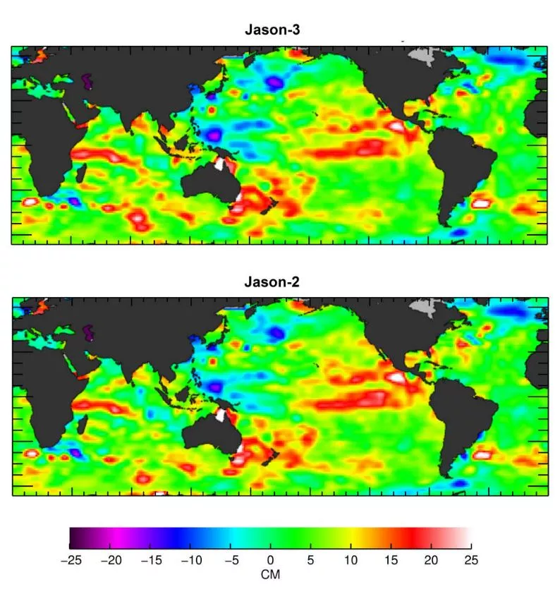
"Jason-3 has completed a nearly flawless first year on orbit," said Eric Leuliette, NOAA Jason Project Scientist and acting branch chief for the NOAA Laboratory for Satellite Altimetry. "During a very successful seven-month calibration/validation phase, Jason-3's instruments were precisely compared to those aboard Jason-2 as both missions flew over the same track roughly 80 seconds apart. Those comparisons allowed for a seamless transition of measurements of sea level, wave height, and ocean winds from Jason-2 to Jason-3."
So with Jason-3 in the driver's seat in regard to measurements of sea level, will Jason-2 spend the rest of its days in the shadow of its newer sibling?
Not quite, said Leuliette.
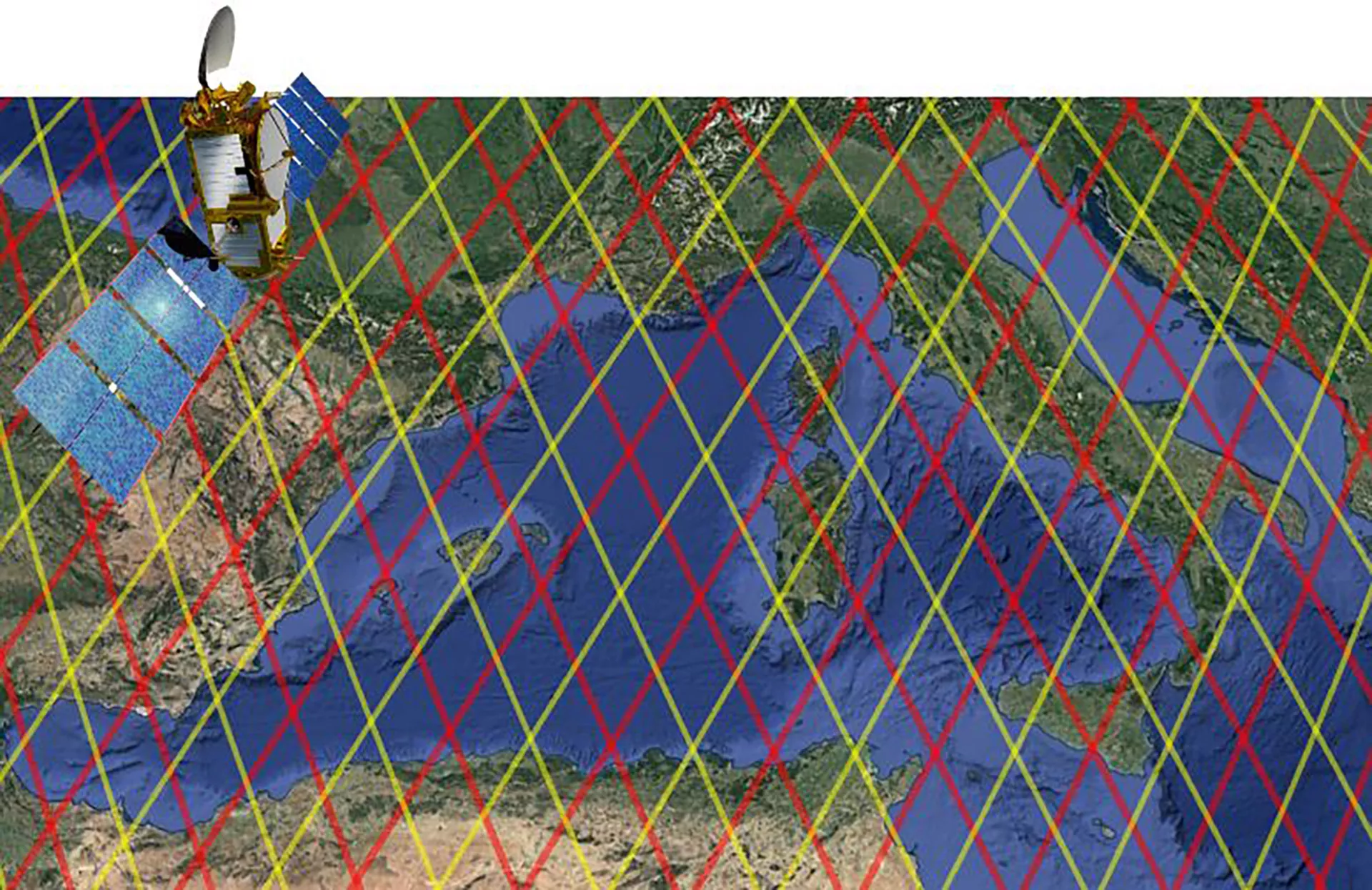
"In mid-October Jason-2 was moved so that its ground track interleaves with that of Jason-3 (see graphic at top), optimally doubling the Jason satellites' observations of the ocean." (A ground track is the path on Earth’s surface that’s directly below a satellite as the spacecraft orbits.) "With twice the coverage, the Jason missions are resolving small eddies and ocean currents, and are more accurately mapping the current La Niña conditions in the Pacific," he said. "Working together, Jason-2 and Jason-3 will improve the intensity forecasts during the [2017] Atlantic hurricane season."
NOAA began continuous monitoring sea level more than 20 years ago, with the TOPEX/Poseidon satellite in 1992. Jason-1 took over in 2001 and then its successor, Jason-2, took the helm in 2008. Like its predecessors, Jason-3 produces estimates of the global mean ocean height for 95 percent of the world’s ice-free oceans every 10 days.
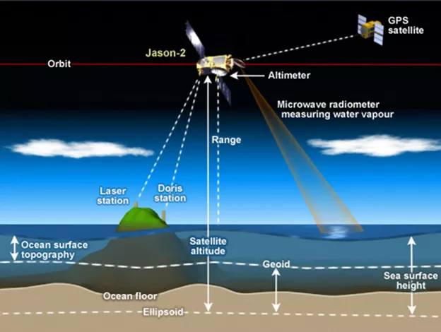
Satellites measure ocean height with the help of instruments known as radar altimeters. These devices allow scientists to calculate ocean surface height (aka; sea level) by measuring the time it takes a radar pulse to make a round-trip from the satellite to the sea surface and back.
NOAA launched Jason-3 in 2016 to ensure the continuity of this important environmental data record and, once operational, the satellite flew in tandem with Jason-2, 830 miles above Earth's surface, collecting comparable measurements of sea surface height down to the sub-centimeter level. Since the start of the TOPEX/Poseidon mission in 1992, researchers have observed global sea-level rise at a rate of 3.2 millimeters a year, resulting in a total change of 77 mm—or 3 inches—in 24 years.
In addition to sea surface height, Jason-2 and -3 also collect on wave height and ocean winds—data used in a variety of commercial and practical applications, such as hurricane intensity forecasting, surface wave forecasting for offshore operators, tides and current forecasting for commercial shipping and ship routing, coastal forecasting for response to environmental problems like oil spills and harmful algal blooms, and El Niño and La Niña forecasting.
The Jason satellite program is a joint effort among NOAA, the National Aeronautics and Space Administration (NASA), France’s Centre National d’Etudes Spatiales (CNES) and the European Organization for the Exploitation of Meteorological Satellites (EUMETSAT). To learn more about it, visit the NESDIS and NESDIS STAR websites.